The Okie Legacy: The Tsenacommacah

Soaring eagle logo. Okie Legacy Banner. Click here for homepage.

Moderated by NW Okie!

Volume 16 , Issue 44

2014

Weekly eZine: (374 subscribers)
Subscribe | Unsubscribe
Using Desktop...

Sections
Alva Mystery
Opera House Mystery

Albums...
1920 Alva PowWow
1917 Ranger
1926 Ranger
1937 Ranger
Castle On the Hill

Stories Containing...

Blogs / WebCams / Photos
NW Okie's FB
OkieJournal FB
OkieLegacy Blog
Ancestry (paristimes)
NW Okie Instagram
Flickr Gallery
1960 Politcal Legacy
1933 WIRangeManuel
Volume 16
1999  Vol 1
2000  Vol 2
2001  Vol 3
2002  Vol 4
2003  Vol 5
2004  Vol 6
2005  Vol 7
2006  Vol 8
2007  Vol 9
2008  Vol 10
2009  Vol 11
2010  Vol 12
2011  Vol 13
2012  Vol 14
2013  Vol 15
2014  Vol 16
2015  Vol 17
2016  Vol 18
2017  Vol 19
2018  Vol 20
2021  Vol 21
0  Vol 22
Issues 44
Iss 1  1-1 
Iss 2  1-8 
Iss 3  1-20 
Iss 4  1-27 
Iss 5  2-4 
Iss 6  2-11 
Iss 7  2-17 
Iss 8  2-25 
Iss 9  3-6 
Iss 10  3-23 
Iss 11  3-31 
Iss 12  4-7 
Iss 13  4-14 
Iss 14  4-21 
Iss 15  4-28 
Iss 16  5-11 
Iss 17  5-19 
Iss 18  5-27 
Iss 19  6-3 
Iss 20  6-9 
Iss 21  6-16 
Iss 22  6-23 
Iss 23  6-30 
Iss 24  7-28 
Iss 25  8-4 
Iss 26  8-12 
Iss 27  8-18 
Iss 28  8-25 
Iss 29  9-1 
Iss 30  9-9 
Iss 31  9-15 
Iss 32  9-23 
Iss 33  9-30 
Iss 34  10-6 
Iss 35  10-13 
Iss 36  10-20 
Iss 37  11-4 
Iss 38  11-11 
Iss 39  11-18 
Iss 40  11-24 
Iss 41  12-1 
Iss 42  12-9 
Iss 43  12-15 
Iss 44  12-22 
Iss 45  12-31 
Other Resources
NWOkie JukeBox

The Tsenacommacah

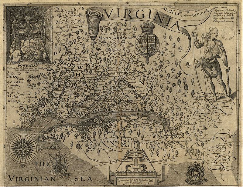
Tsenacommacah (speak: Sen-ah-cóm-ma-cah, variously spelled as Tenakomakah, Tscenocomoco, Tsenacomoco, Attanoughkomouck, and Attan-Akamik - 'densely inhabited land') is the name given by the Powhatan Indians to their native homeland, the area encompassing all of Tidewater Virginia and parts of the Eastern Shore.

More precisely, its boundaries spanned 100 miles (160 km) by 100 miles (160 km) from near the south side of the mouth of the James River all the way north to the south end of the Potomac River and from the Eastern Shore west to about the fall line of the rivers. View the zoomable virtual version of the John Smith map modified by Edward Wright Haile.
  |  View or Add Comments (0 Comments)   |   Receive updates ( subscribers)  |   Unsubscribe


© . Linda Mcgill Wagner - began © 1999 Contact Me