|
Moderated by NW Okie! |
Volume 15 , Issue 222013Weekly eZine: (374 subscribers)Subscribe | Unsubscribe Using Desktop... |
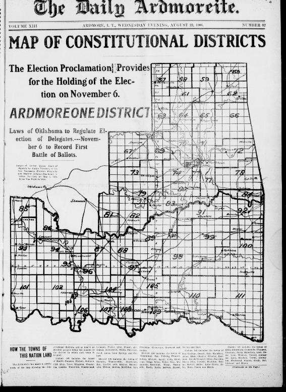
1906 Indian Territory Map of Constitutional Districts

In The daily Ardmoreite, dated Wednesday, 22 August 1906, on the front page, there was a map of Indian Territory constitutional districts. The election proclamation provided for the holding of the election on November 6, 1906.
The laws of Oklahoma would regulate election of delegates, November 6, 1906 to record first battle of ballots. Judges of United States Court of Appeals for Indian Territory to define necessary election precincts and appoint Judges, residency in Indian Territory on May 6, 1905 gave you right to vote.
The Ardmoreite had made a careful study of the map showing the constitutional districts and as nearly as possible gave the number of the district in which each town was located:
District 107 included the towns of Madill, Simpson, Kinlock, Oaklaca, Cliff, Shay, tyler, Kingston, Weaverton, Lonelm Woodville, Cumberland, Lebanon, Plater, Linn, Powell, Adams, Aylesworth, Willis, Pickwick, Mead, Amos, Isom Springs and Colbert.
District 106 included the towns of Marietta, Thackerville, Overbrook, Ran, Enville, Bob, Hoxbar, Burneyville, Wilson, Bowles, McMillan, Ark, Provence, Greenville, Durwood and Holder.
District 104 included the towns of Tishomingo, Ego, Folsom, Filmore, Belton, Milburn, Egypt, Viola, Emet, Cope, Truax, Wiley, Teller, Try, Wapanucka, Randolph, Wyattville, Ravia, Baum, Berwyn, Russet, Norton and Earl.
District 102 included the towns of Fox, graham, Oswalt, Milo, Woodford, Abner, Dixie, Chagris, Wheeler, Eastman, Sneed, Newport, Glenn, Marsden, Deese, Pike, Cornish, Healdton, Eolian, Hewitt, Keller, Lone Grove, Atlee, Reck, Cheek and Brock.
District 101 included the towns of Ryan, Petersburg, comanche, clay pool, courtney, Parks, Rubottom, Loco, Oscar, Leon, Woolsey, Terrell, Addingcar, Leon, Woolsey, Terral, Addington, Fleetwood, Sugden, Grady, Orr, Linwood and Simon.
Other districts and towns are mentioned on page four of The Ardmreite.
| View or Add Comments (0 Comments)
| Receive
updates ( subscribers) |
Unsubscribe
| © . Linda Mcgill Wagner - began © 1999 Contact Me | |
