|
Moderated by NW Okie! |
Volume 13 , Issue 102011Weekly eZine: (374 subscribers)Subscribe | Unsubscribe Using Desktop... |
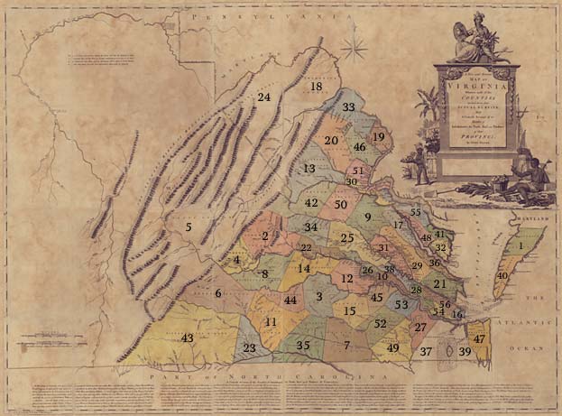
Virginia County Boundaries 1770

The illustration of Virginia County boundaries, uses as a base map where most of the counties are laid down from actual surveys. With a concise account of the number of inhabitants, trade, soil and produce of the province. Counties listed without boundaries defined are represented without colorfilled areas and counties are listed below. SEE ALSO Early Virginia Maps
Virginia County Boundaries:
1. Accomack County -
2. Albemarle County -
3. Amelia County -
4. Amherst County -
5. Augusta County -
6. Bedford County
7. Brunswick County -
8. Buckingham County -
9. Caroline County -
10. Charles City County -
11. Charlotte County -
12. Chesterfield County
13. Culpepper County -
14. Cumberland County -
15. Dinwidie County -
16. Elizabeth City County -
17. Essex County -
18. Frederick County
19. Fairfax County -
20. Fauquier County -
21. Gloucester County -
22. Goochland County -
23. Halifax County -
24. Hampshire County
25. Hanover County -
26. Henrico County -
27. Isle of Wight County -
28. James City County -
29. King and Queen County -
30. King George County
31. King William County -
32. Lancaster County -
33. Loudon County -
34. Louisa County -
35. Mecklenburg County -
36. Middlesex County
37. Nandsemond County -
38. New Kent County -
39. Norfolk County -
40. Northampton County -
41. Northumberland County -
42. Orange County
43. Pittsylvania County -
44. Prince Edward County -
45. Prince George County -
46. Prince William County -
47. Princess Ann County -
48. Richmond County
49. Southampton County -
50. Spotsylvania County -
51. Stafford County -
52. Sussex County -
53. Surry County -
54. Warwick County -
55. Westmoreland County -
56. York County
| View or Add Comments (0 Comments)
| Receive
updates ( subscribers) |
Unsubscribe
| © . Linda Mcgill Wagner - began © 1999 Contact Me | |
