|
Moderated by NW Okie! |
Volume 16 , Issue 212014Weekly eZine: (366 subscribers)Subscribe | Unsubscribe Using Desktop... |

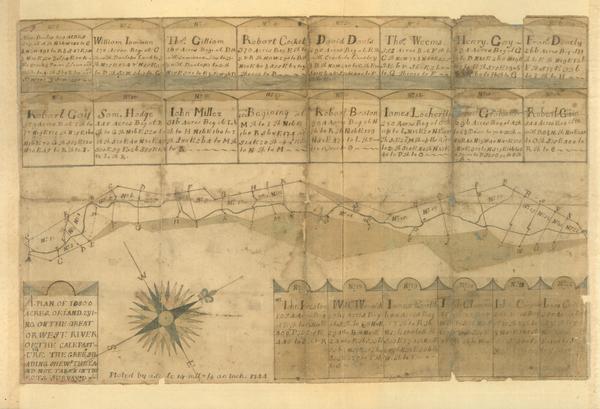
1744 Plat of Calf Pasture Settlement
Concerning the Calf Pasture Settlers in Virginia -- All here are Irish -- all are Presbyterians, according to description of the people of Augusta County, from a letter written by a Presbyterian minister.
In 1744 a plat of the Calf Pasture settlement (shown left, above) was made for Colonel James Patton. A 544 acre piece of land, Lot #16, is designated for Robert Gwin (1720-1785). The original map is part of the Lyman Draper collection of the Wisconsin Historical Society.
Whether the new settlers arrived at Belle Haven or Hobbe's Hole, they must have soon moved on towards their final destination: the Calf Pasture tract. The settlers may have spent the Winter of 1738-39 on the Beverley estate but probably not at the expense of Beverley or Patton. Instead, Patton appears to have supported the settlers with William Lutwidge's credit.
By September 1739, Lutwidge began to realize what had happened after going over Patton's accounts. When the ship Walpoole returned to Whitehaven in October, 1739, Lutwidge replaced Patton with another captain.
In a December, 1739 letter to James Johnson in Virginia, Lutwidge wrote, "I must own that I have met with both knaves and fools in plenty, but of all ye Knaves I ever met, Patton has outdone them all. James Concannon can tell you of his viloney which I dare not repeat; he charged no less than 6,000lbs of fresh Beefe in Virginia, 40 barrels Indian corn and everything else in proportion, took 15 servants to himself at a clap. In short, Hell itself can't outdo him."
On April 27, 1742, the Council of Virginia recognized that James Patton, a partner in the venture, had at his great expense transported Several Families from the North of Ireland in order to comply with the condition of the said Order. The Council noted that 36 families were transported and settled on the lands.
In 1745, seven years after the arrival of the Walpoole in Virginia, Patton along with Lewis and Beverley sell the Calf Pasture tracts to the settlers. It is worth noting that the contract of indenture of Peter Burke was for a period of seven years beginning on the date of his arrival in Virginia, August 23, 1738.
Robert Gwin purchased 544 acres from Col. James Patton & John Lewis, 16 Jul 1745, deed recorded in Orange County, Virginia (Deed Book 10, p. 104-6).
Col. Patton was killed by Indians, 8 Jul 1755, during French & Indian War, at his home in Draper's Meadow, now part of the campus of Virginia Tech University.
What people fail to realize is that the 1744 plat of Calf Pasture, Augusta County, Virginia, with Robert GWIN noted on 2nd row (last plot) is dated 1744. The survey to develop this map, had to of occurred several years prior to 1744.
Therefore the 1745, deed record is a mute point for placing Robert Gwin in the area, other than being the 1st official document. One must therefore research the development of Calf Pasture to really understand.
| View or Add Comments (0 Comments)
| Receive
updates ( subscribers) |
Unsubscribe
| © . Linda Mcgill Wagner - began © 1999 Contact Me | |