|
Moderated by NW Okie! |
Volume 16 , Issue 42014Weekly eZine: (366 subscribers)Subscribe | Unsubscribe Using Desktop... |

New Madrid, Missouri Earthquakes (1811-12)
New Madrid earthquakes -- Three of the earthquakes were on the list of America's top earthquakes: the first one on 16 December 1811, a magnitude of 8.1 on the Richter scale; the second on 23 January 1812, at 7.8; and the third on 7 February 1812, at as much as 8.8 magnitude.
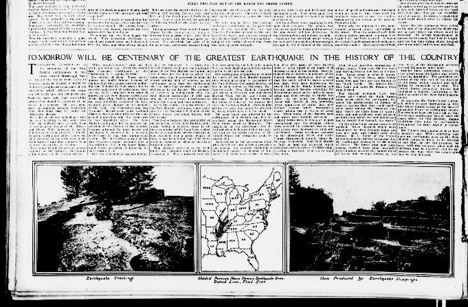
In The Sun, New York City, NY, dated 15 December 1912, page 50, there was this headline: "Tomorrow Will Be Centenary of the Greatest Earthquake In History of the Country." It mentioned, "December 16th as the century of the New Madrid earthquake in the great central Mississippi Valley."
They reported that should the region from Cairo to Memphis again be skunked it would be definitely prophesied recurrence of the convulsions which affected the same area 100 years ago and 200 years ago. Scientists were saying that succeeding earthquakes should be expected at intervals of a century. The area comprised an unstable geologic formation, which had what may be called the earthquake disease.
The San Francisco and Charleston, SC earthquake of 1886 were not to be compared with what was known as the New Madrid earthquake of the Mississippi Valley, which, during the year following 16 December 1811, wrought great changes in the surface of the land.
The Charleston and San Francisco disturbances were national disasters because they affected the congested population nd the structures in two important cities. The New Madrid earthquake left no marked impression on the history of the country, because although far more severe and prolonged, it occurred in a sparsely settled and at that time unimportant region. The lower Mississippi Valley earthquake persisted at intervals for more than a year, while the San Francisco quake occupied only a few minutes.
It was back then, few years before, that the late Prof. Nathaniel S. Shaler of the United States Geological Survey said, "Analogies indicate the probability of the recurrence of the New Madrid earthquake within a century, since in all these countries which have been visited by great convulsions, where observation has extended over a great length of time, it has been found that their visits must be expected as often as once in a hundred years."
The area which was affected by the earthquake of a century ago (1811) lies irregularly along the Mississippi River from Cairo, south to Memphis. The magnitude of the disturbance would be realized whiten it was stated that throughout half of the entire expanse of the United States the vibration could be plainly felt.
A geographer, Flint, visited the area a few years after the shocks, and reported the country exhibited a melancholy aspect of chasms, of formerly rich lands covered two or three feet deep with sand, of trees thrown down or lying tipped at an angle of 45 degrees or split in the middle.
Descriptions of the occurrence in a report of the United States Geological Survey said that the earth rolled in waves several feet high, with deep depressions between the swells, finally bursting and leaving parallel fissures extending for distances as great as five miles in some cases and from twenty to thirty feet wide.
At one point the Mississippi River was broken in two, admitting great quantities of water into new formed chasms which immediately closed, giving rise to waves of great size. From many of the fissures sand and water (sand boils) were forcibly extruded.
Many forms were in whole or in part precipitated into the streams, others were covered by extruded waters and still others were depressed or sunk and overflowed. Great wreckage occurred on the Mississippi River, and entire islands disappeared, notably island No. 94, near Vicksburg. Near New Madrid a fault or land slip occurred, which stretched entirely across the Mississippi, creating a waterfall from six to eight feet high.
Prof. Shaler described depressions in Obion county, Tennessee, 100 feet deep and varying from a few feet to 100 feet wide. Large areas in what was known as the st. francis Basin sank bodily many feet, and they were known afterwards as the "Sunk Lands." The famous Reelfoot Lake and Lake St. Francis were thus formed.
There was an English geologist, Lyell and others, who visited the "Sunk Lands" some years after the earthquake described the submergence of forests of cypress, saying that they could paddle their boats among the branches and that "there are large trees of walnut, white oak and mulberry, such as grow on high land, which are now submerged ten to twenty feet beneath the water."
Other areas were uplifted. River channels which were frequented by deep draught boats were now dry land, and islands were also formed. M. L. Fuller of the Untied States Geological Survey estimated back then that the earthquake destroyed 150,000 acres of forest. The forest area back then comprised Reelfoot Lake alone originally covered about seventy-five square miles of forest, and swamps formed at the time west of the Mississippi probably covered 125 square miles more.
The timber in other areas was utterly ruined by landslides. The published accounts of the time told of the disorder of the trees, which cracked and split, falling by thousands at a time. The Untied States Geological Survey had published a bulletin containing a detailed account of the New Madrid earthquake.
Mr. fuller found a great oak which escaped destruction in 1811 and which stood still at the base of an ancient fissure or earthquake chasm. The tree was at least 200 years old, so that the former earthquake was at least 100 years before the 1911 disaster. Indian traditions also point to earthquakes though out the same region in earlier times.
| View or Add Comments (0 Comments)
| Receive
updates ( subscribers) |
Unsubscribe
| © . Linda Mcgill Wagner - began © 1999 Contact Me | |