|
Moderated by NW Okie! |
Volume 14 , Issue 82012Weekly eZine: (375 subscribers)Subscribe | Unsubscribe Using Desktop... |

Highland County Virginia - Exploration Of...
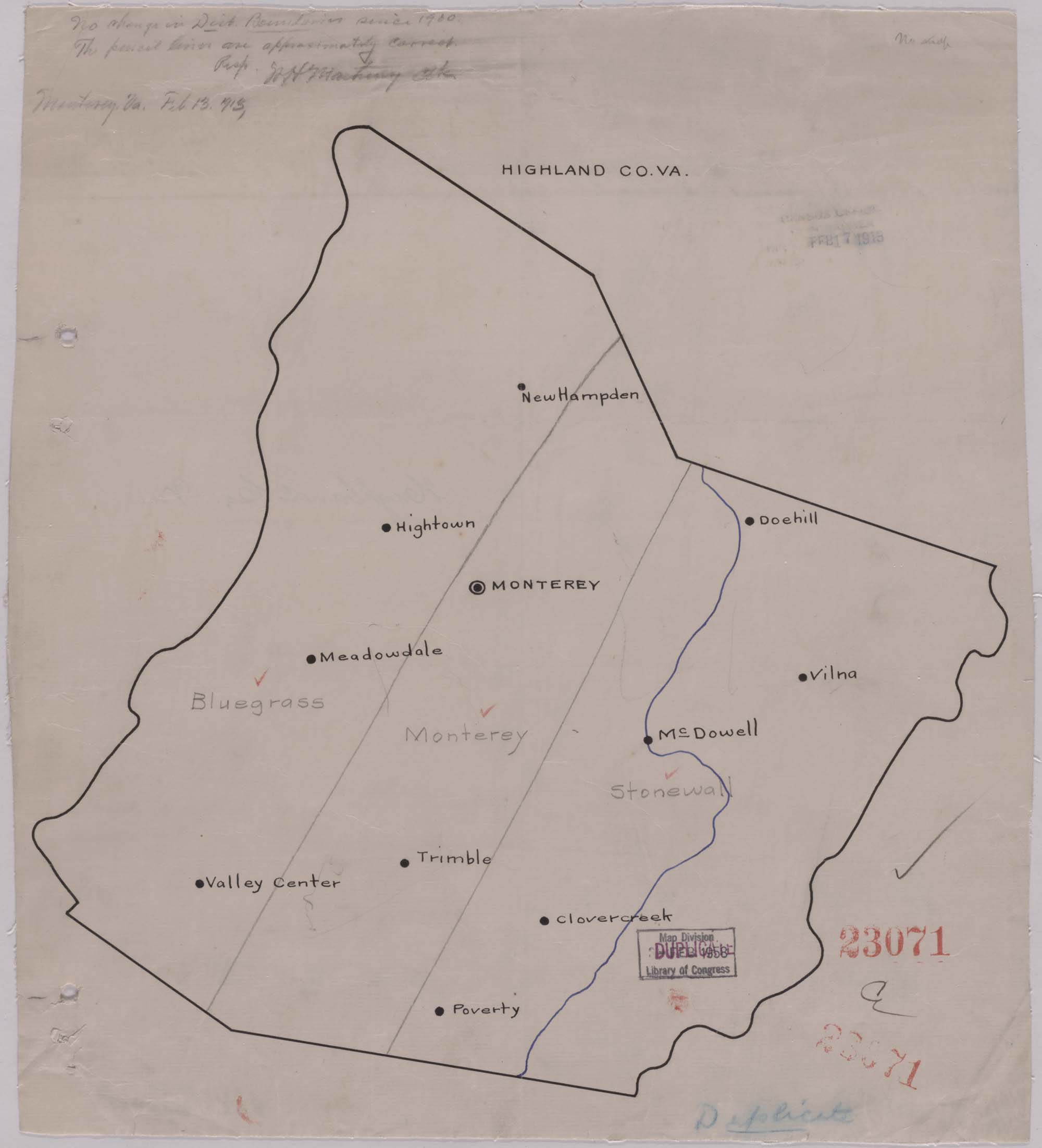
Exploration beyond the mountains is where our next journey takes us in discovering the lands of our ancestry that settled in the Pastures and Valley of Virginia. This is our discovery of Highland County, Virginia where our Gwin, Hohl (Hull), Kincaid and Warwick settled after they they took the journey across the Atlantic Ocean for religious and economic persecution back in the "Old" country back home.
We will begin with Governor Alexander Spottswood of Virginia in 1716 deeming it important to learn the truth regarding this land beyond the Blue Ridge mountains that he supposed lead to only a few days march to the Great Lakes. Spottswood was not impelled by curiosity or far-sightedness, though. It was the land hunger which impelled the American step by step to the Pacific that was making itself felt. It was the pillaging of the Tidewater soil had begun to counsel a decisive exploration beyond the mountains.
Governor Spottswood left the capital with a mounted party of 50 companions following no road the greater part of the distance. It took him from August 20, until September 5, 1716 to cover a distance of 220 miles. The Spottswood party encountered many rattlesnakes while climbing the Blue Ridge mountains through Swift Run Gap. On the summit they found trees blazed by the Indians. Spottswood and his party descended to near where Elkton now stands as they reached a fine river which they named "Euphrates. They crossed to the left bank and held a banquet the next day, September 6, 1716. To chronicler the expedition it is careful to enumerate the considerable variety of wines and liquors which had been brought along. Each toast was followed with a volley from their firearms.
BUT . . . Governor Spottswood and the "gentlemen" of the party did not go any farther. Some rangers were left behind to prosecute the exploration. At the disbanding at Williamsburg, after an absence of eight weeks, the governor took steps to present each of his companions with a miniature horseshoe of gold containing the Latin motto, Sic juvat transcend ere montes Translated it is, So let it be a joy to pass over the mountains.
It was not the swilling of liquor or the presentation of badges that were the results of the expedition, though. They instead found a highly inviting region. On the mountains they crossed and on those they saw in the blue distance were noble forests. Between was a broad, grassy prairie with a more fertile, homelike soil than that of Tidewater. The wilderness was abound with game and fish, and there was no Indian village within a hundred miles. The land beyond the mountains was now officially and practically discovered and attractive reports of the same were soon circulating in Europe. In 1720 another county was formed and named Spottsylvania, in honor of the governor and took in the locality he visited.
The governor declared that his chief purpose was to assure himself that it was practicable to reach the Great Lakes. According to Indian reports they could be seen from the mountains in the distance. Surprising as it was Spottswood did not push on to those mountains to see for himself, instead he merely wrote in his official recommendation that settlements be established on the Lakes and communication secured by means of a chain of forts. In any cue, it was the passing through meadow of tall grass to look for another where the grass might be a bit taller. Spottswood was good even though it came to nothing. Other men were more practical than Spottswood.
The exploration of the great Valley of Virginia and the minor valleys beyond were tolerably rapid. By 1727 the Cowpasture Valley had been prospected, and a year or two earlier a Dutch trader by the a name of John Vanmeter has ascended the South branch as far as the vicinity of Franklin. Another Dutch explorer, John Vanderpool, discovered the gap which bears his name, and told of a beautiful valley beyond with impassable mountains in the distance. While hunters and rangers were prospecting this land of promise, a new wave of immigration was setting in, destined within a half century to supply the colonies with at least a fifth of their whole population.
In 1732, George Washington was born and the Scotch-Irsih and the Germans had only begun to float across the Atlantic. six hundred thousand people already were in the lowlands of Virginia and had nowhere penetrated the Alleghany watershed.
Some of the Scotch-Irish arrived at Charleston and went direct to the Carolina uplands. The greater share of the immigrants of both nationalities came to Philadelphia, because of the reputation of the Pennsylvania colony for its civil and religious liberty. The district along the Delaware River and westward toward the mouth of the Susquehanna was quite well occupied by a substantial class of English Quakers. The people already here looked with distrust on the stance appearing immigrants from Ireland and Germany. These newcomers that were not bound to servitude had therefore pushed inland through the zone of settlement.
The earlier colonists did not receive the new immigrants with wide open arms, they liked the Scotch-Irish the less of the two because of their assertive manner. Restrictive laws were accordingly passed. The Germans were required to adopt English names, which appears to explain the s=wholly English form of the surnames of not a few of the German pioneers.
Many of the newcomers made only a short stay i Pennsylvania. They moved to the southwest, because in this direction lay the door of wider opportunity. The Germans, lovers of peace and on the whole the less aggressive of the two races, remained in Pennsylvania and occupied the inland districts as far as the western rim of the Cumberland Valley. The overflow pushed through that valley into the adjacent section of Maryland, across the Potomac into the valleys of the Shenandoah and the South Branch (then known as the Wappacomac).
The Germans occupied the west side of the Shenandoah Valley as far southward as the vicinity of Harrisonburg. In the valley of the south Branch, the attempt of Lord Fairfax to make his extensive grant a feudal barony of the English pattern caused many of the immigration to push above Fairfax boundary, which lay in the vicinity of Moorefield and Petersburg.
The Scotch-Irish we find were more numerous and more venturesome and their area of their distribution was much wider. They occupied the western section of Pennsylvania, and filled the Valley of Virginia southward of the German district. They also filled the Valley of East Tennessee, but they took possession of the uplands of both the Carolinas. They became a frontier community, which extended from the vicinity of the Great Lakes southward into Georgia. Their development of this frontier was quite rapid and greatly hastened the westward advance of the American people.
The Scotch-Irish pathfinders were particularly fixed on that section of the Valley of Virginia which lies southward of Massanutton Mountain. They occupied this region in force. Their earlier selections were not int he smooth, open plain between the mountains. Why was it they should appear to scorn fettle lands that needed no clearing? Their motive was substantially the same as that which led the earlier settlers beyond the Missouri to shun the open prairie and ling to the creek bank, where drinking water had only be be dipped out of a spring and where timber was at hand for shelter and fuel. The limestone plain in the valley was deficient in surface water. The Scotch-Irishman did not shirk at the trouble of felling trees, but he had no mind to dig a deep well if he could help it.
In 1727, a year before the first permanent settlement in Rockingham, and five years before there was anybody at or near where the city of Staunton grew up, we find an attempt to colonize the Cowpasture Valley. It was in that same year that Robert and William Lewis, Willaiam Lynn, Robert Brooke, and Beverley Robinson petitioned the Gvoernor and Council to with the following:
This is where we find in the very same year when the first actual settler came to the Shenandoah Valley, there was an earnest effort to colonize the Highland area. This was only 120 years after the landing at Jamestown, when the entire population of the Colonies did not equal the present number of people int he city of Baltimore. BUT . . . was the above petition sever granted? It is doubtful, but in 1743 there was an order of council in favor of Henry Robinson, James Wood and Thomas and Andrew Lewis, for 30,000 acres in the same region.
There were considerable number of Scotch-Irish in the upper Shenandoah Valley by this time and even southward. In 1738, the region west of the Blue Ridge had been set off into the counties of Augusta and Frederick, with the line between the two crossing the Shenandoah Valley in the vicinity of Woodstock. The county machinery of Augusta was not set in motion until the close of 1745. It was during this interval that Augusta remained attached to the parent county of Orange.
We find that the Augusta colony was the starting point of the Scotch-Irish settlement of upper Virginia. The dispersion from this center was governed by the position of the gaps in the mountains. Pioneer travel never climbed a steep rocky ridge when it was possible to find a grade line along a crooked watercourse.The settlers did not go over the rugged Shenandoah Mountain as they moved westward into Bath and Highland, but they flanked it by way of Panther Gap, 30 miles southwest of Staunton.
Highland was settled by the Scotch-Irish land seekers coming through Panther Gap and along the upper James, moving up the valleys of the Cowpasture and Jackson's River, until they reached the laurel thickets along the cross rigs separating the waters of the james from those of the Potomac. The German land seekers cam from the opposite direction as they crept up the three valleys of the South branch waters until they had come to the divide. Likes attracted likes in the settlement of a new region. Pioneers of the same class preferred to be together.The Scothc-Irish and the German settlers were not like oil and water, but in communities of either the other was in some degree represented.
In the pioneer days of Highland we find these two defined areas of settlement. The Scotch-Irish filling the vie valleys which opened southward and the Germans occupying Straight Creek and the Crabbottom. A few of them made homes south of the divide, with a larger number of the Scotch-Irish settling north of it. When Pendleton county was established in 1787, its southern line folioed this water-parting. It was not only a natural geographic boundary, but it was also a boundary between tow provinces of settlement. Pendleton was predominantly German. Bath would soon be sticker off and was distinctly Scotch-Irish.
In the valleys of the Cowpasture, the Bullpasture, Jackson's River, and Back Creek, the family names were mainly Scotch-Irish. In the Crabbottom and in Straight Creek, family lineage was mainly German but thoroughly Americanized. There had been much blending of the two. Some families not German innate had become almost German in blood, while the present generation of the German immigrant cannot point back to an unmixed German ancestry. Northeast of Highland the divide passes very near the county boundary. Crossing into Pendleton one finds a large number of the people using a broken down German idiom. South of the divide it is an unknown speech never having much foothold.
Besides families coming from the east of Virginia, some even came from the distant New England. We find that Welsh, French and Celtic and saxon irish scattered freely though out all the colonies, without seeking to found distinct settlements of their own. The venturesome Hollanders of the New York colony were not quite unrepresented. The actual beginnings of settlements in the counties of Highland and Bath show the latter county lying directly against the gateways to the Valley of Virginia. The settlement of BAth was a bit earlier than that of Highland. The Cowpasture valley was first reached and first settled, while the valley of Back Creek came last, just as we might suppose. The German influx did not reach the divide as soon as the Scotch-Irish. There were people at the head of the Bullpasture 15 years before there appears to have been any in Crabbottom.
The Calf Pasture Valley lies eastward across the mouth of panther Gap, and it was supposed that settlement would be a little earlier than in the valleys beyond. It was on Arpil 2, 1745, when deeds for 2,247 acres were given by James Patton and John Lewis to William Campbell, Jacob Clemens, Samuel Hodge, Robert Gay, Thomas Gillam and William Jamison.
August 17, 1745, other deeds for 5,205 acres were given by the same men to Francis DONALLY, Robert GWIN, Robert BRATTON, John DUNLAP, Loftus PULLIN, John WILSON, John KINCAID, John MILLER, Robert GAY and James CARTER. Almost all these names occur shortly afterward in Bath or Highland, though purchaser himself or a son. Of those names I see many that connect to my paternal ancestry. Such as GWIN, BRATTON, DUNLAP, KINCAID and GAY. [Click the following link for more information on my pioneer ancestry at Paris Pioneers Genealogy. Is there anyone out there researching their ancestry roots of Highland county, Virginia that have you ever come across any of the miniature, inscribed, "gold horseshoes that Governor Spottswood handed out to his travel companions that we mentioned earlier in this article?
On the South Fork in Pendleton we have knowledge that number of German families, to whom deeds were given on one and the same day, had been living on their lands ten years and in recognized occupancy, yet the lands had already passed into private ownership.There was no record any permit for those persons to settle, though. The authorization would seem to have been verbal and for a definite term of years. The country beyond the Shenandoah ridge and above the confluence of the Cowpasture with Jackson's River, we find that in 1744 a survey of 176 acres a was granted to one William Moor on the last named stream and in what is now Alleghany county. The following year ten other persons took surveys on the Cowpasture below Williamsville.
In 1746, nineteen more surveys were recorded for the lower Cowpasture, thirteen for Jackson's River, and five for Back Creek. All these appear to be below the Highland line. How long these people had been here, we do not know with any certainty. John Lewis was directed by the Orange court, May 23, 1745, to take the list of tithables for the district between the Blue Ridge and the North (Shenandoah) Mountains, "Including the Cow and Calf Pastures and the settlers back of the same." It is not conclusive that any settlers had actually gone beyond the Cowpasture. The order was worded so as to include all settlers, however far to the west they might be found. Aside front he report of the county surveyor, there seems to be no evidence that people had located west of Shenandoah Mountain prior to the coming of Moor in 1744, or perhaps 1743.
The order of council in favor of the LEWIS and their associates was granted in 1743. Adam DICKENSON's Fort stood four miles below Millboro and appears to have been the leader of the settlers on the lower Cowpasture. Dickenson was a large landholder and on the organization of Augusta in 1745 he became one of its first justices.
| © . Linda Mcgill Wagner - began © 1999 Contact Me | |