|
Moderated by NW Okie! |
Volume 13 , Issue 352011Weekly eZine: (366 subscribers)Subscribe | Unsubscribe Using Desktop... |

Oklahoma History Refresher
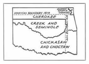
Did you know... That until 1819 on the north and 1824 on the east, Arkansas claimed the boundaries of northern and eastern Oklahoma indicated by the broken lines in the Oklahoma map view to the right.
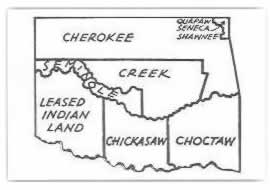
From 1855 to 1866... state lands were divided among the tribes of the Cherokee, Creek, Seminole, Leased Indian Land, Chickasaw, Choctaw, and the Quapaw - Seneca - Shawnee. As seen in this 1855 to 1866 Oklahoma Map. (Click Link for Map View).
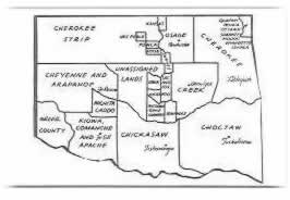
By the time of the "Run"... In April, 1889, Oklahoma had been divided as shown in the 1889 Map of Oklahoma. (Click Link for Map View) The Unassigned Lands in central Oklahoma were opened for homesteading at that time. It included the Unassigned Lands; the Cherokee Strip in the northwest; the Osage (Pawhuska); the Cherokee (Tahlequah); the Cheyenne and Arapahoe (Ft. Reno); the Creek (Okmulgee); the Wichita Caddo; Greer County; Kiowa, Comanche and Apache (Ft. Sill); Chickasaw (Tishomingo); Choctaw (Tuskahoma); etc...
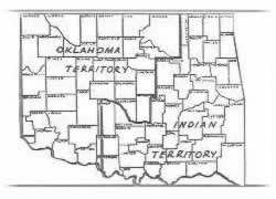
Prior to statehood... In 1907 there was Oklahoma Territory in the northwest and Indian Territory in the southeast... As shown in the Oklahoma Map prior to 1907 statehood. (Click Link for Map View).
According to a history of "Watonga 1892-1992", by Frank J. Moudry, Oklahoma was originally the land of Indians. It was occupied almost solely by Indians from the early 1800's until 1889. As progress and civilization moved westward it was opened to white settlement. There were nine great land openings...
- April 22, 1889... The Unassigned Lands or "Old Oklahoma."
- May 2, 1890... No-Man's Land or Panhandle was opened by the Organic Act.
- September 22, 1891... Sac and Fox Reservation, Iowa Reservation and Pottawatomie-Shawnee Reservation.
- April 19, 1892... Cheyenne - Arapaho Reservation.
- September 16, 1893... Cherokee Outlet, Pawnee Reservation and Tonkawa Reservation.
- May 25, 1895... Kickapoo Reservation.
- January 1897... Old Greer County, by the Greer County Homestead Act.
- August 6, 1901... Kiowa - Comanche - Apache Reservation and Wichita - Caddo Reservation.
- 1906... Big Pasture, 500,000 acres reserved from original Kiowa - Comanche - Apache Reservation.
| © . Linda Mcgill Wagner - began © 1999 Contact Me | |