|
Moderated by NW Okie! |
Volume 5 , Issue 92003Weekly eZine: (366 subscribers)Subscribe | Unsubscribe Using Desktop... |

Sections
|
Blogs / WebCams / Photos
|
Volume 5
|
Issues 9
|
Other Resources
|
Okie's NW Corner

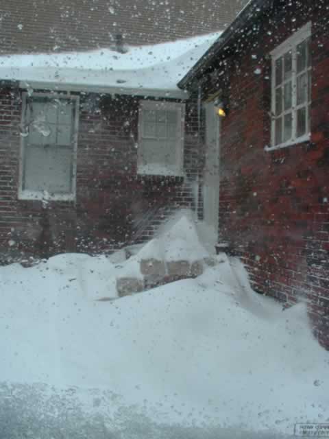 Last
weekend Old Man Winter stopped by in the Northern parts of the state
to let us heartlanders know that Winter was still with us for awhile
at least. This is one of the pictures taken at my backdoor with
the snow drifts piling up in the early morning hours of Sunday,
23 Feb. 2003.
Last
weekend Old Man Winter stopped by in the Northern parts of the state
to let us heartlanders know that Winter was still with us for awhile
at least. This is one of the pictures taken at my backdoor with
the snow drifts piling up in the early morning hours of Sunday,
23 Feb. 2003.
We do get snow once in awhile here on the heartland plains of Northwest
Oklahoma. Here's another photo that finds swirling snow drifts decorating
the southeast corner of my back porch. Last Sunday morning (23 Feb.
2003) I was greeted with 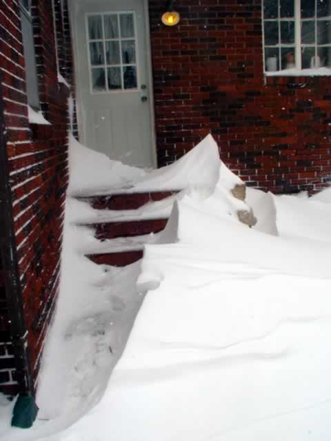 blowing,
drifting snow blowing in from the northwest. This Winter deep-freeze
had set it sights on Northern Oklahoma, but by 4:00 p.m. that Sunday
afternoon, the sky was clear, sunny, but windy -- the streets were
worn with slushy, worn tire tracks. By Monday the clouds were still
there, highways were ice-packed and temperatures were in the 10
degree range.
blowing,
drifting snow blowing in from the northwest. This Winter deep-freeze
had set it sights on Northern Oklahoma, but by 4:00 p.m. that Sunday
afternoon, the sky was clear, sunny, but windy -- the streets were
worn with slushy, worn tire tracks. By Monday the clouds were still
there, highways were ice-packed and temperatures were in the 10
degree range.
Also... in the early Sunday morning hours the OkieLegacy.net reached it's milestone of 100,000 visitors. When I turned on my computer around 9:00 o'clock a.m., Sunday morning, the visitor counter read 100,049. During the morning of Feb. 25th, 2003, the visitor counter had reached the 100,790 milestone.
As To Alva Pioneer Tidbits of 1904... F. C. Langley of Alva was the Second man to register at Kiowa, September 1893, as a candidate to enter the promised land, for better or worse -- K. H. Kendal, 1904 postmaster and merchant at Galena, 25 miles south of Alva, opened the first bakery in Alva -- April 1, 1894, Alva postoffice was made a money order office -- 1st Post office and Postmaster in Woods county... The first postoffice ever opened in what is now Woods county was at Waynoka in 1892, and B. F. Spalding, the Santa Fe station agent there, was the postmaster. The office was established to accommodate the cattlemen who had possession of the country at that time. W. A. Childress was the fist station agent, and he was put in charge of the Waynoka station in, was one of the greatest cattle shipping points in the world.
Reminiscence of an Oklahoma Run... This little pioneer story came from the Medicine Lodge Index, dated Oct. 4, 1903 -- "It was on a Saturday evening in the early 1900s that the course of a conversation between Tip McCracken of Elwood and Sam Stewart of this northwest township, recalled a run into the Strip, in the fall of 1893. They each made a run of forty-five miles and covered the entire distance in two hours and thirty minutes. They started from Kiowa and each landed on a quarter on what was then the T-5 Ranch. The horse Mr. Stewart rode was still living and was in 1904 owned by D. C. Funk. The presence of the horse on the street at that time reminded Stewart and McCracken of the incident. Mr. McCracken's horse died only a short time before 1904. If there was such a thing as horse heaven he was certainly wearing a crown. Tip thought so much of the horse that he had saved the hoofs and polished them to keep them as a relic of his famous ride of 1893. The long ride and fast time did not injure the horses in the least and they were on duty the following day. There are few records equal to this one and the owners of those two horses have license to be just a little proud."
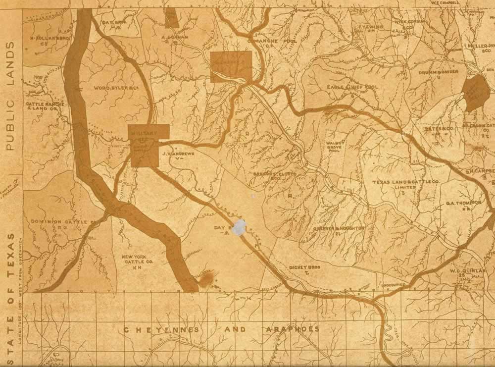
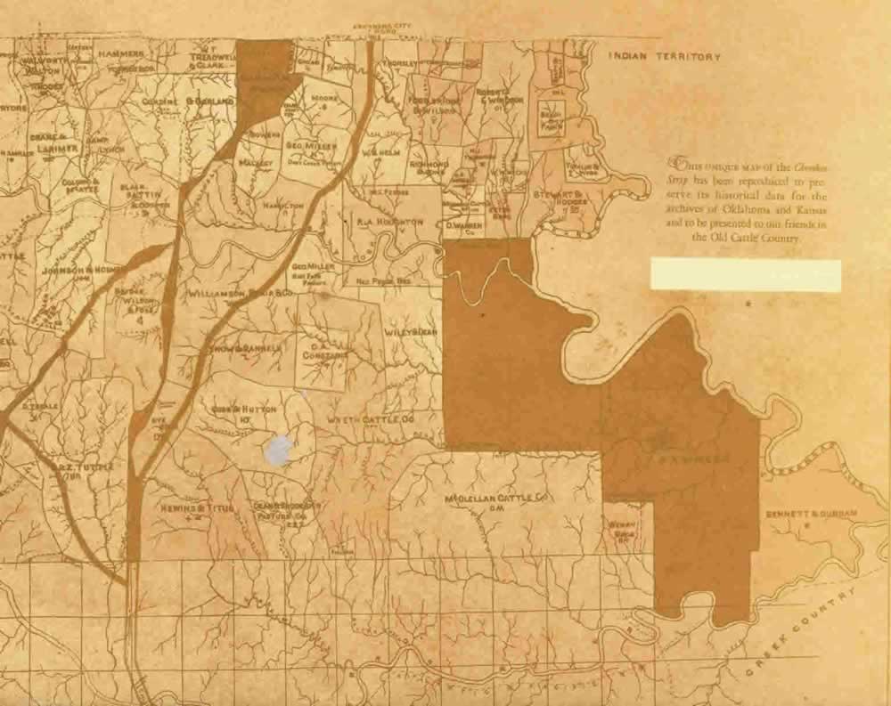
Map of Cherokee Strip, Indian Territory - 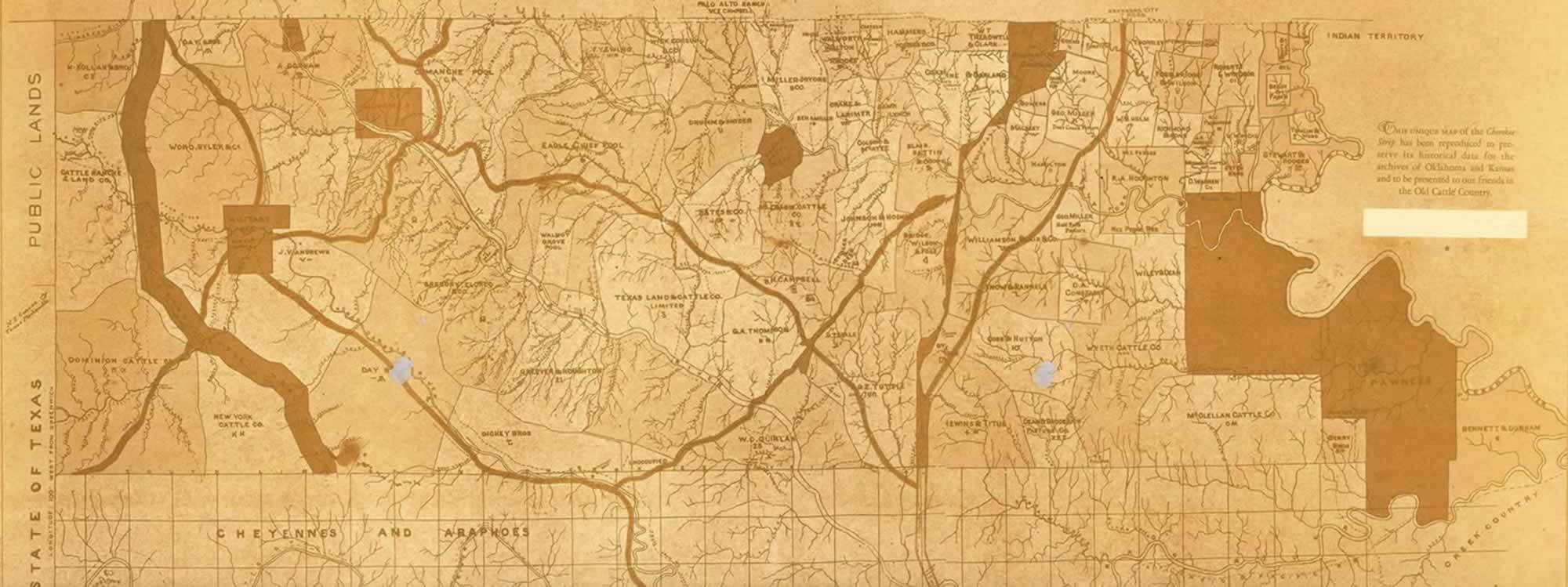 Leased
by Cherokee Strip Live Stock Assoc. from the Cherokee Nation.
This unique map of the Cherokee Strip had been reproduced
to preserve its historical data for the archives of Oklahoma and
Kansas and to be presented to the friends in the Old Cattle country.
We are not sure the exact date of this reproduction. CLICK the photo
for a larger, whole view of map. For a smaller view of the map for
your computer screen - CLICK the West
side and the East
side of the Cherokee Strip map. Over on the western part of
the map near the Cimarron River you will see a wild cat creek...
That Wild Cat Creek runs through our Fairvalley land.
Leased
by Cherokee Strip Live Stock Assoc. from the Cherokee Nation.
This unique map of the Cherokee Strip had been reproduced
to preserve its historical data for the archives of Oklahoma and
Kansas and to be presented to the friends in the Old Cattle country.
We are not sure the exact date of this reproduction. CLICK the photo
for a larger, whole view of map. For a smaller view of the map for
your computer screen - CLICK the West
side and the East
side of the Cherokee Strip map. Over on the western part of
the map near the Cimarron River you will see a wild cat creek...
That Wild Cat Creek runs through our Fairvalley land.
Ranches, Ranges, Cattle Trails & Cattle Co.... The Cherokee Strip was bordered on the west by public lands (No Mans Land) and the NE corner of the Texas panhandle. On the southern border was the Cheyenne & Araphoes and Creek country. On the north it was bordered by Kansas. The Arkansas River cutting a boundary line on the east side.
Here are some of the Ranches, Ranges and Trails that made up the Cherokee Strip Live Stock Assoc....
| H. Kollar & Bro. Cattle Ranch & Land Co. Dominion Cattle Co. Texas Cattle Trail Day Bros. Word, Byler & Co. Military Res. (Camp Supply) New York Cattle Co. A. Gorham J. Vandrews Day Bros. Comanche Pool Gregory, Elored & Co. Dickey Bros. Eagle Chief Pool Walnut Grove Pool Greever & Houghton F. Y. Ewing Texas land & Cattle Co. limited W. C. Quinlan; unoccupied Wick Corbin Drumm & Snider Bates & Co. B. H. Campbell G. A. Thompson Miller-Pryors & Co. Great Salt Plains Cragin Cattle Co. Walworh Walton & Rhodes Crane & Larimer Colson & McAtee Johnson & Hosmer D. T. Beale T. & Z. TuttleCanteen & McDaniels Hammers, Forbes & Co. Camp Lynch Blair, Battin & Cooper Bridge, Wilson & Foss Dye Bros Hewins & Titus W. T. Treadwell & Clark Saline Res. |
Corzine & Garland Quarantine Grounds Bowers Macaley Hamilton Williamson, Blair & Co. Snow & Rannels Cobb & Hutton Dean & Broderick Pasture Co. Gozao Forsyth Moore Barefoot Geo. Miller Geo. Miller Salt Fork Pasture Wyeth Cattle Co. C. A. Constable T. E. Sullivan R. A Houghton W. B. Helm Wiley & Dean McClellan Cattle Co. T. Horsley McCrady Crocket Holt bros. Foss Bridge & Wilson Richmond & Sons Roberts & Windsor N. J. Thompson S. P. Burgess Michigan Cattle Co. D. Warren W.W. Wicke Estes Bros. Beach & Fagan Stewart & Hodges Tomlin & Webb Ponca Res. Pawnee res. Berry Bros. Bennett & Dunham |
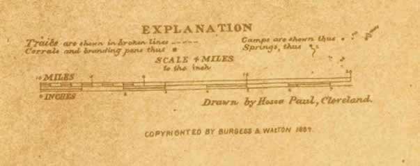
This map was compiled from surveys of ranges made for the Association in 1888 by S. T. Wood, Fred Eckert, T. W. Walton and C. H. Burgess, and is believed to contain the best information accessible concerning the location of ranches, camps, range lines, etc., on this lease. The trails, corrals, branding pens, camps and springs are also shown in the Legend of the 1888 map. The map shows it was drawn on a scale of 4-miles to the inch by Hosea Paul, Cleveland, Ohio. The publishers were: Burgess & Walton - Publishers, 1884 - C. H. Burgess, 18 Pub. Sq., Cleveland, Ohio; T. W. Walton, Caldwell, Kansas.
It's that time of year almost when the March winds blow and the citizens of communities around the Heartland get out their kites, strings and keys to experience and take advantage of the mighty winds that blow across our state. Will March come in like a Lion or Lamb?
Either way... Let's Go Fly a Kite! See Y'all next weekend around the same time. Do NOT let the March winds blow you away!
~~ Linda "oaKie" ~~
| View or Add Comments (1 Comments) | Receive updates ( subscribers) | Unsubscribe| © . Linda Mcgill Wagner - began © 1999 Contact Me | |