|
Moderated by NW Okie! |
Volume 10 , Issue 302008Weekly eZine: (366 subscribers)Subscribe | Unsubscribe Using Desktop... |

WWII - Colmar Pocket Map
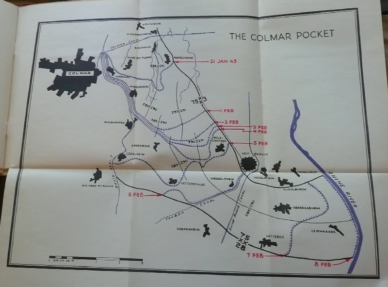
The Colmar Pocket date was 1-7 January February 1945. To the people of France, the continued German hold on the Colmar district of Alsace was an intolerable threat to national pride and security. The French first Army was accordingly directed to liquidate the pocket. The 75th Infantry division, battle-hardened by its month in the Ardennes, was assigned to assist in this mission.
"The battle of Colmar was characterized by the peculiarity of the terrain. The Rhine Plain at this point was about seven miles wide, the greater portion lying on the west side of the Rhine. High mountains overlook the plain from both sides of the river and were intervisible. Excellent enemy artillery observation into the valley was provided by these mountains. Cover in the plain was provided by deciduous forests and villages. Short range cover was provided by a slight rolling of the ground. The action began with about a foot of snow covering the plain, and one to ten feet lying in the mountains. it was completed in a mid-winter thaw that resulted in severe flooding. After the thaw, tank action was not bogged down because tanks sunk through 8 to 12 inches of topsoil mud to a gravel bed underneath.
"The mission of the division was to cover the right flank of the 3d Infantry Division in its drive south along the Rhine. The most advanced elements of the 28th Infantry division were several thousand yards northwest of Colmar and the most advanced elements of the 75th Infantry Division several thousand yards southeast of Colmar. The picture was presented of a division attacking with its left and center, and having its right echeloned to the rear in a line that grew thinner and thinner as the division progressed. never, until the latter days of the engagement, did the rear elements of the division have more than a few infantrymen between themselves and the enemy, and on one occasion the defense paltoon and the reconnaissance troop were all that lay between the Division Command Post and the enemy across the L'ill River....."
| View or Add Comments (0 Comments)
| Receive
updates ( subscribers) |
Unsubscribe
| © . Linda Mcgill Wagner - began © 1999 Contact Me | |