|
Moderated by NW Okie! |
Volume 14 , Issue 162012Weekly eZine: (366 subscribers)Subscribe | Unsubscribe Using Desktop... |

Highland County Virginia - Towns, Villages & Hamlets
We continue our little history of Highland Valley of Virginia with the mention of a few town, villages and hamlets. We find that Highland was organized in 1848 with 4,000 people and the only center which might be termed a village was the little place of McDowell. It was more properly considered a hamlet than a village, though.
Natural conditions foreshadowed the village which grew up on the Bullpasture. There was a gorge on the left bank of the river that was an easy ascent to the top of the Bullpasture plateau. Crab Run, meet the river at right angles, providing a still more easy approach to the Straight Creek Valley. At the intersection of the two streams was a large area of bottom land and low table, on the right side of the larger stream. In 1832, the place was known as Sugar Tree Grove. At that time it contained a Presbyterian church, a store, a schoolhouse, a sawmill, a blacksmith shop, and a few dwellings.
By 1860 it contained several more houses, such as the brick residences of Felix K. and George W. Hull. The schoolhouse was still a log building. The Stage came every other day. and the tavern had little custom, except from people passing through the county. Some years earlier it had received its present name in honor of one of the Virginian governors.
The battle bought on the ridge above in 1862 gave it a name abroad but nothing more substantial. Yet while the census of 1910 registered a six per cent decrease in the population of Highland, it showed a slight increase in that of McDowell. The place had two churches, a schoolhouse of three rooms, three stores, a hotel, a blacksmith shop, two saddler shops, and twenty-six families. Two rising industries were the large, modern flouring mill at the iron bridge, and the tannery which was taking form just below.
It was the spring of 1848 that the site of Monterey was an opening in the woods and laurel thickets on the saddle between the two Straight Creeks. Here was a solitary dwelling on the pike which followed the crown of the saddle. As far back as 1774, Samuel Black appeared to have had a cabin in the near vicinity, and a portion of his patent was included within the corporate boundary. The site of Black's cabin was unknown in 1911. Maybe someone today has determined that location.
The decision to put the county seat at Monterey was enough to insure the early appearance of a village. The log house owned by James Bell and occupied by John Cook became a temporary courthouse and was also the first tavern. The turnpike was sixty feet broad and was quite straight, known as High Street. The town site was load off by Bell covered thirteen acres, including the public lot of three acres. The house lots were made 72-½ by 200 feet.
Samuel Ruckman, one of the justices, proposed the name Highland, and it was at first adopted, yet almost at once gave place to that of the Mexican city where General Taylor had just won a victory. The meaning of the Spanish term Monterey was the same as that of the French term Montreal -- "Kingly" or "Royal" Mountain.
When the war came on (1863) Monterey was a village of about one dozen houses, mostly log. One of the very oldest of these, standing a little above the Bishop store, was torn down in 1911. ON the rise of ground just east of the cemetery of 1911 stood the brick academy, afterward succeeded by an adobe structure just north of J. A. Whitelaw's.
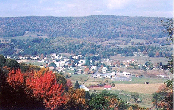
The half century since the outset of the war, but far more especially the last two decades have witnessed the clearing away of the woods in the hollow between the bordering mountains, and the steady evolution of the place itself into one of the handsomest small towns of the state. In descending the slope of Jack Mountain one catches a glimpse of a seemingly compact village of red-roofed and white walled houses of substantial size embowered in rows of handsome shade trees. The original courthouse was enclosed by an iron fence and flanked on one side by a new jail, was still in use and suffices ordinary needs, in 1911. The log houses of an earlier day had either been leveled or their walls had been covered with weatherboarding.
The stores, shops and offices of Monterey were in number and variety about what might be expected in a town of its size. The High school was a modern building provided with an auditorium. The Masonic Temple was an imposing brick structure near the center of the town. Of the two hotels the Monterey House was a commodious three storied building, its size being significant of the attractive summer climate. Considerable local wealth was represented in Monterey, and the financial interests of the county and town were cared for by two banks.
The situation of the county seat on a saddle extending a mile from one mountain ridge to another and parting the waters in opposite directions, was very sightly. Thus the town was at once on a hilltop and in a valley. In the north was a handsome vista, embracing the valley of Straight Creek, but reaching well into Pendleton, and disclosing at the left the Devil's Backbone on the father side of the Crabbottom Gap. In the south the view was dominated by Sounding Knob, rising 1,300 feet above sea level.
If the turnpike had followed the cAmpbell survey, the three mountain ridges would have been avoided, and tot he greater ease of travel. Sugar Tree Bottom would have had to compete with a village at the mouth of Davis Run, and the county seat would have grown up at the lower entrance of Vanderpool Gap. The situation on Jackson's River would have given the town more ids trial advantage, though proving somewhat less sightly and picturesque. The steam flouring mill of Monterey would have been represented by a water mill.
Ten miles north of Monterey, and just above the upper entrance tot he Crabbottom Gap was the village of Crabbottom (where NW Okie's HULL/HOHL ancestry settled) called into being by the well-peopled and and wealthy basin beyond and the tributary region below. At Crabbottom there were three general stores, a water mill, two churches, a high school, several shops and about tenth families. Crabbottom was along while known as Hull's Store, and was but a mere hamlet until after the war.
If you go about a mile up the Crabbottom VAlley you might reach the somewhat newer village of New Hampden, a place half as large as the lower village, and also possessing a mill, a hotel, and a resident physician, but with one church and one store. New Hampden as laid out about 1858 by Dr. Life and others and had a regular appearance, in contrast with the village which grows up by chance along a crooked road.
Doe Hill was eight miles above McDowell, at the confluence of the three brooks which form the Bullpasture River. It took its name from the foothill ridge near by, on which many doe could often be seen.Oliver McCoy shot nine deer one morning before breakfast and within sight of his house. Doe Hill was an old place, having possessed a church and a store earlier than 1835. It once had a mill and a tannery. Its academy had a short career, unfortunately, and was on the border of the little village, a place with church and two-roomed school, two stores, hotel and about a dozen families.
Bolar lies in the narrow Bolar Gap, and is partly in Bath county. The county line approximating the course of the highway running through the gorge. The name came from Colonel John Bollar of Bath, whose wife inherited the land from her father, William Wilson. The place was no more than a hamlet, there being only seven families, although two or three stores and several boarding houses were found at Bolar. The chief interest of the locality lies in its mineral springs, the largest and best known of which was at the country pine on the land of Adam G. McGuffin. These mineral springs were at the base of a steep hillside, in which the thermal spring had a temperature of 74 degrees and an outflow of 52 barrels a minute. In the basin the waters had a greenish tinge and bubbles of gas were constantly rising. The discharge passed into a bath house and filled to a depth of four feet a tank 24 to 42 feet in dimensions.
This spring did not appear to have had a quantitative analysis, but it appeared to contain arsenic, iodine, chlorine, potassium, sodium and carbonic acid gas, besides a few other ingredients. In ailments of the skin and of the internal lining tissues the water had been found to have a very beneficial effect. Taken as a beverage it was diuretic and alternative and mildly aperient. At an early day it was found to be a speedy cure for itch and poison oak. Many people had derived great benefit in cases of eczema and other cutaneous affections, but in nasal catarrh its repute was even higher.
A mile above another thermal spring was found in 1910 on the land of J. Hamilton Burns. This spring was of less volume, but had a temperature of 79 degrees and appeared to be rather stronger in mineral properties than the other, in addition to containing lithia in small amounts. The curative effects of this spring appeared to be identical with those of the lower spring.
At the Eakle House was a mildly thermal soda spring, very wholesome as a beverage and beneficial tot he digestive organs. Still lower down was a cold spring of sweet chalybeate water, and toward the mouth of Bolar Run were two sulphur springs.
Bolar was frequented in some degree by summer guests, but not as much so as would be the case if it were still better known and more easy of access. The cool, shaded valley, swept by downward draft of air through the gorge was very conformable during a heated season.
Today Monterey, Virginia is located on U.S. Route 250, which was built through the area in the 1840's as a portion of the historic Staunton-Parkersburg Turnpike which linked the upper Shenandoah Valley with the Ohio River. The town of Monterey is heavily dependent on agriculture and on niche tourism generated from its many events and shops catering to tourists visiting for the tranquility and mountain air. The biggest festival is the < href="http://www.highlandcounty.org/maplefestival.html">Highland County Maple Festival, held on the 2nd and 3rd weekends of March, which brings roughly 50,000 visitors to the area.
| View or Add Comments (0 Comments)
| Receive
updates ( subscribers) |
Unsubscribe
| © . Linda Mcgill Wagner - began © 1999 Contact Me | |