No Man's Land
This week's epistle, as some would say, concerns some
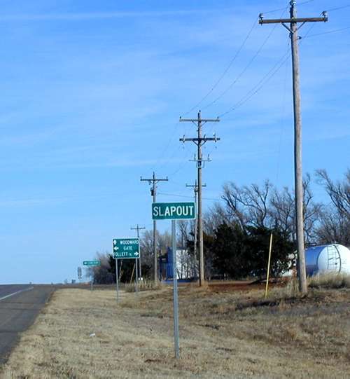
history of "No Mans Land," tidbits and pictures of Slapout
(aka Nye), southeast corner of Beaver County, easterly part
of the Oklahoma Panhandle, along highway 270.
Slapout, OK
BUT... Before we get
to Slapout in nowhere, let us explore some history of this place they
call "No Mans Land." Where Buffalo used to roam, before squatters,
cattlemen, farmers, and homesteaders seeked this area for new adventures.
Speaking of buffalo, I just had to throw in a picture of a white buffalo
that I captured in Colorado and brought back to Oklahoma. Of course
it is NOT a real buffalo, but what a beautiful rendition of this famous
white rarity of good luck that now graces my fireplace mantle with
honors. White Buffalo
white buffalo
According to "The Panhandle History - Northwest
Flats Heritage, 1890-1990", published in 1990, the panhandle is a
little more than 34 miles wide and a fraction longer than 168 miles.
It contains 5738 square miles and is larger than Connecticut and 4-1/2
times the size of Rhode Island.
The Panhandle is bordered on the east by Oklahoma;
the north by Kansas and Colorado; the west by New Mexico and the south
by Texas. It was a part of the Texas territory until 1850, when Texas
gave it up because everything north of the 36th parallel went with
the Union and Texas permitted slavery.
The south boundary line of the Kansas territory was
established around 1854... The east and west lines established previously
by land grants. The Act establishing the Kansas southline completely
legislated the panhandle strip of land out of the Union and left "No
Mans Land" to fend for itself.
By 1885... The Supreme
Court decision come out stating that this strip of land was NOT part
of the Cherokee Outlet. The Secretary of Interior at that time stated
it was "Public Domain" and subject to "Squatters Rights."
Until 1891... The six-shooter was law of the
land and the strip became a "No Mans Land" haven for criminals
and outlaws. May 2, 1890 and the Enabling Act signed by President
Benjamin Harrison attached the strip to Oklahoma Territory. Then the
farmers and the ranchers were at it because of the fence the farmers
were building around their crops.
Finally, "No Mans Land" found it's permanent
home and was the last territory to be given final claims and ownership
in Oklahoma. It was divided into three (3) counties -- Cimarron,
Texas and Beaver.
Cimarron County... Is
on the westerly side of the strip with Boise City as the county seat.
Cimarron County is known for good farm lands and rough rugged grassland.
There are only 3070 counties in the USA, but only one called Cimarron
County. It touches four (4) states and in 1990 there was NOT
a stop light in the county. Also thirty (30) miles northwest
of Boise City you will find the "Black Mesa State Park"; Dinosaur
bones that have been dug up and tracks still visible in the creek
beds. Did you know that Boise City is the only city in the continental
USA that was bombed during WWII? Sounds like another mystery to unravel,
huh? I am NOT sure why it was bombed, but maybe someone out there
reading this could enlighten us with their own little "epistle
of knowledge."
Texas County... After
traveling through Cimarron County, we come to Texas County. It is
the middle county and one of the most prosperous counties in the midwest.
It is the center of the largest sweet gas field in the USA. They do
cattle feeding, irrigation and dryland farming. The main line of the
Rock Island RR from Chicago to Los Angles runs through Guymon, which
is the county seat. Highways 54 and 64 also intersect this panhandle
metropolis in the middle of nowhere. Texas County was the geographical
center of the 1930s Dust Bowl. Parts of "Grapes of Wrath" were
filmed north of Guymon.
Beaver County... If you
keep headed east on the highway in No Mans Land, you will reach the
easterly county named Beaver. The town of Beaver is a small agricultural
community with it's share of oil & gas production and is also famous
for it's "World's Champion Cowchip Throwing Contest." It is
also the county seat of Beaver County. If you head east along highway
270 in the southeastern part of Beaver County, you will come to our
next stop... Slapout
(a.k.a. Nye).
As the story goes...
According to a written family history of one of the pioneers (Joseph
L. Johnston), written by his son and namesake, Joseph L., for
the "History of Beaver County Pioneer Families," Vol. I & II,
published in 1970 by the Beaver County Historical Society... Joseph
L. Johnston came to Beaver County in 1902 and filed on a quarter section
now known as the Slapout community. He brought is bride, Edith, to
the claim in 1904. They raised wheat, dairy cattle and six sons and
one daughter... Sidney N., Maxwell L., Jessie M.
(daughter who married Grover Mettler, 1st male child born after
statehood), Joseph L., James F., Arlie W.,
Donald E.
Slapout was built on part of Joe and Edith's claim.
Joe was one of the early store owners of the General Store and Gas
Station. Joe and Edith were well known throughout the country for
helping travelers, friends and neighbors in need during WWII. Joe
died in 1950 in an untimely auto accident and Edith died in 1965.
November 1, 1997, http://www.kwtv.com
with Randy Renner reporting, aired a segment on "Oklahoma's Strangely
Named Towns" concerning Slapout
(a.k.a. Nye). Follow the link to see how Joe "Slapout"
Johnston and Tom "Nye" Lemmons were both stubborn enough that
neither of them would give in. How in 1949, a tornado blew through
the town... All of Tom's "Nye" signs were blown down and Joe's "Slapout"
signs survived through a divine intervention which settled the issue
once and for all in Slapout, Oklahoma.
| View or Add Comments (0 Comments)
| Receive
updates ( subscribers) |
Unsubscribe
